| |
Directions
|
Miles
|
| 1. |
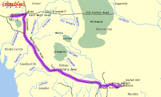
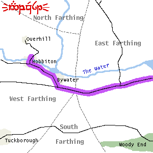
Start out going South from THE HILL. |
0.6 |
| 2. |
Cross THE WATER. |
1.0 |
| 3. |
Turn. LEFT onto ROAD TO BYWATER |
9.3 |
| 4. |
Turn LEFT onto EAST ROAD, toward FROGMORTON |
47.8 |
| 5. |
Cross BRANDYWINE BRIDGE |
0.1 |
| 6. |
EAST ROAD becomes EAST-WEST ROAD toward BREE |
106.3 |
| 7. |
Turn RIGHT onto GREENWAY toward DUNLAND |
359.1 |
| 8. |
Cross R. GWATHLÓ/GREYFLOOD |
0.5 |
| 9. |
GREENWAY becomes NORTH-SOUTH ROAD |
415.0 |
| 10. |
Ford R. ISEN at FORDS OF ISEN |
90.5 |
| 11. |
Cross R. SNOWBOURNE |
219.0 |
| 12. |
Cross MERRING STREAM |
330.4 |
| 13. |
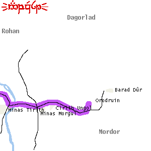
At MINAS TIRITH, turn LEFT toward MINAS MORGUL |
120.8 |
| 14. |
Continue East toward CIRITH UNGOL. |
37.3 |
| 15. |
Bear East-North-East toward ORODRUIN |
84.7 |
| 16. |
Climb UP toward CRACKS OF DOOM |
19.4 |